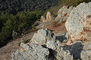
Geography & Geology
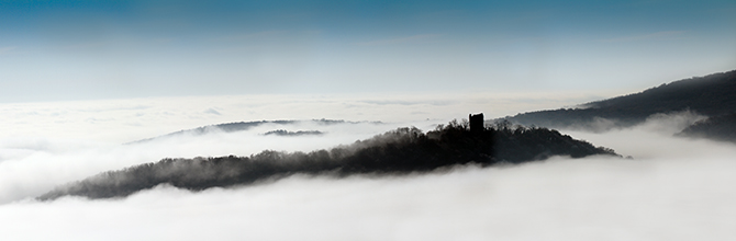
Fruska gora is located between 45° 0’ and 45° 15’ of latitude, and 16° 37’ and 18° 01’ of longitude, in the direction of parallel between rivers Danube and Sava. This mountain chain is about 80 km long; the widest part of the chain has the width of 15 km. The highest pick of the mountain is Crveni cot (549 m), but the chain looks massive because it surmounts ambient which is lowland.
Geological structure
The geological structure of Fruska Gora is, compared to some other regions, relatively complex. The oldest segments are serpentinites. According to some authors, they are products of changed gabbro peridotites, the age of which is Paleozoic. Besides serpentinites, there are other Paleozoic rocks such as philitites, mica. chlorite, amphibolic and other shales.
The distribution direction of shales is, generally, West - East, declining to the South.
On the surface, they appear in the central parts of the mountain. On the north side. The main belt of the Paleozoic products is mostly limited to the sediments of the upper Cretaceous. In the westernmost part it is bordered by the Miocene sediments, and in the south by the Quartar sediments. The contact of serpentinites with Paleozoic shales are, as a rule, tectonic in character.
In the framework of the Mesozoic, there are three rocks: of the Triassic, Jurassic, and Cretaceous ages. The Triassic age rocks had for a long time been classified as Paleozoic. Only after fossil remains had been found, was their Triassic origin confirmed. The oldest are conglomerates, and then follows a series of purple and yellow sandstones, purple, gray and yellow clays and clay-sandstones; limestones. According to some researchers, the so called slate-phyllite series (mudstones, clay shales, slates, slate-phyllites, quartz shales and partially metamorphic limestones) also belong to the upper Triass.
In the Fruska Gora, lower, medium and upper Pliocene are developed. In lithological terms, the lower Pliocene sediments are represented by sands, sandy clays, less frequently by grovels and lignite. The deeper facies are made of marls and marl clays.
A part of the flysch series is of the Jurassic age. It has been confirmed by some recent research works, although the well known scientist Koch thought that there were no Jurassic sediments in the Fruska Gora and that lower Cretaceous sediments were nonexistent.
In a thick series of upper Cretarrous sediments there are:
-
basal conglomerates and large grain brecca changing upward to small grain conglomerates and large grain sandstones;
-
gray mudstones, sandstones and alternating conglomerates;
-
reddish marl limestones, lime marls and gray marl; reef-like firm sandy gray limestones: gray, brown and black mica marls, clays and clayey, sandstones and arlcvrolites, with a very rich fauna.
The Cretaceous sediments are clearly stratified, except for brecca. The Cretaceous sediments have a broad range. They have been discovered in the east and north-east part of the Fruska Gora, in several smaller or larger profiles, in the terrains of Strazilovo, Sremski Karlovci, Paragovo. In places, taking the form of shoots, they appear in several locations eastward, all the way to the Danube.
The research in the tertiary sediments in the Fruska Gora have shown that the previously separated "socanski" layers of the Oligocene actually belong to the Miocene. Sediments of this age have particularly been interesting in the study of the Vrdnik coal basin, because the coal and the sediments surrounding it are of the Miocene age. Lower, medium and upper Miocene are developed.
At the beginning of the Quartar there were two large paleo-geographic units: land and water. The land consisted of the mountain slopes and the water unit consisted of the remains of the water basins that had existed earlier. In such conditions, the Quartar sediments were deposited both on the land and in the water.
Loess appears in the form of a relatively thin cover. The highest elevations on which it is found are about 400 m, and from there it covers the surface part of the terrain all the way to the alluvial plains of the Danube and Sava.
As a rule, loess can be found in saddle areas between waterways flowing to the north or south, or builds plateaus such as Miseluk, Rovine, Banstol, and many others. Loess comprises several horizons, separated by fossil soils.
It has been generally accepted that loess represents the products of eolian accumulation of fine dust and sand brought by the winds during the cold and dry climate.
Alluvial sediments are found on the northern side of the mountain; they were created as a product of the accumulation of the silt brought by the Danube. The most extensively researched areas of the alluvion are in the sources of water supply in Novi Sad (Adice, Ribarsko ostrvo, Ratno ostrvo, Petrovaradinska ada, etc.). The bottom of the alluvion is mostly composed of gravel and sand. The medium part consists mostly of sands, with thin lens of dust sediments, rarely mud. The surface part mostly consists of dusty sediments, smaller amounts of dust, sandy and muddy sediments.
Magmatic rocks are also elements of the composition. There are the following varieties: trachites, latites, altered peridotites, volcanic tuffs, dacio-andesites, melaphyres, diabases, gabbro. They appear in the form of intrusive penetrations, veins, concordant penetrations, volcanic outspills; they can be of Paleozoic, Triassic, Cretaceous and tertiary age.
Neotectonic activity of the region
In the neo-tectonic terms, the Fruska Gora is a typical horst. Its shape and height have for the most part been formed by a relative descent along the system of longitudinal E-W slits and northward or southward slopes. This basic structural form became separated in the younger tectonic stage, by lateral and diagonal slits, into smaller blocks of different shapes and sizes.
The direction of the main rupture shapes is W-E. Much shorter are the N-S slits, with occasional deviations towards NNE-SSW direction. These are only several kilometers long slits.